 A few months ago, the NYT Sunday magazine ran a profile of architect Daniel Libeskind and his Tribeca loft. (Incidentally, check out that link to his website; there's some pretty hot flouting of web conventions. For example, when you mouse over a link, almost everything on the screen disappears, except a few stray words and the other links. Hmm.) Anyway, the most memorable part of the magazine article was a photo of the interior of his sauna. In it was a very small window, perhaps 18 inches high by 4 inches wide, and through that window the saun-ee could achieve a compactly framed view of the Chrysler Building. How cool is that? The image here shows the architect's rendering of the different landmarks visible from vantages within the loft. Neato.
Friday, August 25, 2006
Architecture / Daniel Libeskind's sauna
A few months ago, the NYT Sunday magazine ran a profile of architect Daniel Libeskind and his Tribeca loft. (Incidentally, check out that link to his website; there's some pretty hot flouting of web conventions. For example, when you mouse over a link, almost everything on the screen disappears, except a few stray words and the other links. Hmm.) Anyway, the most memorable part of the magazine article was a photo of the interior of his sauna. In it was a very small window, perhaps 18 inches high by 4 inches wide, and through that window the saun-ee could achieve a compactly framed view of the Chrysler Building. How cool is that? The image here shows the architect's rendering of the different landmarks visible from vantages within the loft. Neato.
Thursday, August 17, 2006
Radio / The best interview ever
NPR recently did a great story about John Sawatsky, a former journalist who now teaches interviewing techniques to editorial staff at ESPN. Highlights include Sawatsky's obvious dislike for "hard-hitting" interviewers like Larry King, Barbara Walters and Mike Wallace: "Mike Wallace enjoys ... having the question being more important than the answer." Other resources with other targets: Poynter article in which his method is applied White House correspondents, AJR article skewering Sam Donaldson.
The NPR site has loads of interesting additional resources related to the interview, and in a section called "What Makes A Good Interview," you'll find Sawatsky's nomination for the greatest interview of all time. The link is called "CBC Interview With Trucker About Beaver Attack." A sample:
"So ... how did you get this beaver off of you, eventually?"
"Well, I happen to have propane in my truck, so I have a seven-eighths open box-end wrench, and while he [the beaver] was hangin and chewin back there ..."
This piece got me thinking because interviewing and storytelling are important parts of our design process at Cooper. Early in projects, we interview a lot of people, including current and potential users of the product we're designing, experts in the field we're working in, and anyone who may be able to help us understand the background and context of the design. The goal is to build an understanding of the design problem from a human perspective, and to do this we need to get our subjects to open up, to reveal motivations and needs, the deep, personal stuff that underlies the things we do everyday.
Sawatsky's method is pretty much exactly what we try to use: simple, short, open-ended questions, giving space and time to the interviewee to breathe, think and respond. Poynter has some exercizes to get you thinking about how to conduct more effective interviews.
Thx to JK for getting me started on this.
Wednesday, August 16, 2006
Bikes / Key ingredients for interactive bike maps of the future
ByCycle and Bikely both bring bike route mapping to the web, and not a minute too soon. Finding bike routes through cities (especially unfamiliar cities) can be a lonely, scary process of elimination. After much experimentation, the best route often ends up being a patchwork of quiet side streets, alleys, and paths that would be impossible to piece together in advance on a map. Ideally, you'd get to share ideas and information with other cyclists when you're trying to, say, get from the Mission to the Exploratorium for the first time. Yeah, straight up Van Ness is probably not the best way, even though it looks like it on the map.
Online communities to the rescue, right? MySpace and Wikipedia are doing something right; they've both found ways to tap into the motivations of a particular group of people, providing forums to share information and build connections. Exactly what each has done right is anyone's guess. MySpace is ugly, confusing, often annoyingly inconsistent, and generally unusable. Wikipedia is unreliable, badly written and pretty much a total free-for-all. So the bike route mapping thing doesn't need to be perfect, it just needs to provide the right environment and functionality to do the following things:
- Easily post routes. Use the power and knowledge of the bike community to record the best routes around the city. Bikely does this, and they've built a simple, mostly straightforward process. I created a route of my Summits of San Francisco run/ride, and it pretty easy, though the are some fairly unconventional interactions. Kudos to Bikely for getting my mind going on this.
- Edit and annotate any route. Leveraging the knowledge of the group requires an approach like Wikipedia's. Each route should be editable, and annotate-able by the community. This is the only way to get discussion started.
- Emphasize tagging and categorizing routes over naming. Bikely is very free-form right now, and posting routes has quickly become a free-for-all. They recently added tagging, but it's fairly constrained to a few route attributes -- recreation, commuting, urban, rural. A more Flickr-like model, where one tags can be anything related to the route (marin, tiburon, ocean, golden gate bridge, etc), gives people the ability to make their routes findable by their important characteristics. Of course, as much tagging as possible should be automated -- the route length, the streets covered, the cities visited -- all of this should be extractable from Google Maps, right?
- Distribute admin privileges to local experts. People have posted routes that are almost identical, named them different things, and therefore searching for routes brings up lots of repetitive junk. Here's where Wikipedia provides a good way of allowing the community to police itself. A dedicated San Francisco cyclist could ensure that classic routes are established and maintained.
- Provide inline discussion of routes. An additional problem with lots of people posting similar routes is that they're missing the opportunity to have an interesting discussion about that route. There IS knowledge out there that can be brought to the fore! Like Wikipedia, each route should be editable, and those edits of course should be revertable, and there should be a forum for discussion about the route.
- Allow people to support routes. This is the sixth item, but it's really one of the most important. People should be able to join or approve routes, like "friending" someone in MySpace. This is where MySpace comes in. By "friending" a route, so to speak, you give it your approval as safe, really, and you also begin to build your own profile ...
- Provide a user profile page. It's an essential component of MySpace, Wikipedia, Flickr, del.icio.us, etc. People love themselves. They like to aggregate stuff. This site doesn't need to be MySpace, but it does need to provide the notion of a profile, where a user can share something about themselves, and view the routes they've joined or friended or whatever.
There must be more, right?
I got to thinking about this after reading these two interesting pieces on worldchanging.org: ByCycle - Online bike maps and Making Bicycle-Friendly Cities.
Saturday, August 12, 2006
Food / Lakes and cheeseburgers along the PCT


During my hike on the PCT in 2001, my two favorite pastimes were swimming and eating. When I was walking -- which was most of the time -- cool swimming holes and sizzling cheeseburgers filled my daydreams. When my hiking partner, Nick, and I talked, it was more often than not about swimming and eating cheeseburgers: How far to the next river, creek or lake? How long would it take to hitch out to get a cheeseburger at the next road crossing?
As the two attached lists indicate, we found lots of chances to follow these particularly blissful pastimes. Cheeseburger-wise, the best were found in the Cheeseburger Belt, which begins as the Sierras give way to the Cascades in northern California, and ends a little north of Ashland, Oregon. The best of the best in the belt were found at Buck's Lake Lodge near Quincy, the Pines Frosty in Chester (which also has kick-ass shakes), and Lake of the Woods Resort north of Ashland. At the bottom of the list was Belden Town, which shouldn't really be surprising since they don't seem to like hikers too much anyway.
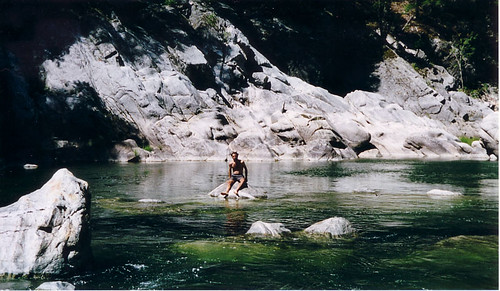
The best of the swimming was between in northern California, between Sierra City and Etna. The Middle Fork of the Feather (pictured below) was spectacular, though Nick preferred Squaw Valley Creek, which he found a little cozier.
Personal history / Pacific Crest Trail five years later
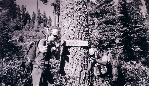
 Five years ago today, I was hiking on the Pacific Crest Trail. I spent the summer of 2001 hiking through California, Oregon, and Washington; on the 12th of August, I was chilling out at Crater Lake, Oregon.
 Crater Lake had been a really major destination for me, not because of its legendary, otherworldly beauty or because I'd never seen it or because I was looking forward to bumming beers off retirees in RVs, but BECAUSE I was having a new pair of shoes delivered to the PO there. My feet, at that point, were thrashed. The trail can be unkind to feet in a variety of ways -- extreme heat in the south, frequent river crossings and snow in the Sierras -- and it doesn't help when you wear one pair of Asics Gel Trabuco III's for the last two-thirds of the state of California.
I take a look at my PCT journal a few times every summer; the entry scanned above represents some of the happier times on the trail. A little earlier in my hike, the heat and drudgery of Northern California would have figured more prominently. The words "heat rash" would have appeared, and I also would have mentioned the fact that my girlfriend was breaking up with me. Later in the hike, my hiking partner, Nick Brown, broke his ankle and some religious zealots crashed commercial airplanes into American landmarks.
Reading over it now, August 12, 2001 represents a distant little period of serenity and calm. My days were pretty simple: How far should I hike today? Where will I get water? Should I stop and take a swim while I'm there? When should I eat my next snack? Should I take this alternate route? Should I stop early? Should I night-hike? Where will I get my next cheeseburger? It amazes me that it ever could be so easy ... The picture below was taken a few days before.
Subscribe to:
Comments (Atom)